
LESS DAYLIGHT INCREASES RISKS FOR PEOPLE WALKING: HOLIDAY SEASON BRINGS INCREASE IN PEDESTRIAN DEATHS AND INJURIES
BALTIMORE, MD (November 19, 2019) – With the approach of Thanksgiving and the winter holiday season, sponsors of Baltimore’s Look Alive pedestrian safety campaign want pedestrians and drivers to make safety a top priority during this risky time of year.
Regional transportation officials warn that November and December are the most dangerous time of year for pedestrians because of fewer daylight hours. According to the MDOT MVA Maryland Highway Safety Office, nearly 70 percent of pedestrian fatalities in Maryland occur in the dark, with one in three pedestrians killed at times with little to no light.
During the last two months of 2018, there were almost 400 crashes involving people on foot in Baltimore and the surrounding counties, resulting in 52 serious injuries and 13 deaths. Pedestrian crashes that result in fatalities occur most often between 6 p.m. and midnight.
“We know visibility plays an important role in pedestrian safety,” said Michael B. Kelly, BMC’s Executive Director. “That’s why we’re reminding everyone to be alert and on the look-out for one another, especially as it gets dark earlier every day.”
Beginning November 21, residents in the Baltimore metropolitan area can expect stepped up enforcement of traffic laws that protect people who are walking. Violators face fines ranging from $40 to $500.
The Look Alive campaign offers safety tips for drivers and pedestrians (see below). The campaign’s key safety tips include reminders for drivers to obey the speed limit and stop for people crossing the street. Pedestrians are advised to use the crosswalk and wear something light or reflective at night. Learn more about the program at LookAliveMD.org.
###
STREET SAFETY TIPS
If you’re driving…
- Slow down and obey the speed limit.
- Stop for pedestrians at crosswalks.
- Be careful when passing buses or stopped vehicles.
- When turning, yield to people walking and biking.
- Look for bicyclists before opening your door.
- Allow at least 3 feet when passing bikes.
- Avoid using your cell phone and never text while driving.
If you’re walking…
- Cross the street at crosswalks and intersections.
- Use the pushbuttons.
- Wait for the walk signal to cross the street.
- Watch for turning vehicles.
- Before crossing look left, right, and left again.
- Be visible.
- Wear something light or reflective after dark.
- Watch out for blind spots around trucks and buses.
- Avoid using your cell phone when crossing the street.
Stage Curtain Systems Maintenance, Repair, Inspection and Installation

2018-2021 TIP - Federal Aid Obligations
2018-2021 TIP - Federal Aid Obligations
BRTB Resolution #20-08
BRTB Resolution #20-08
BPAG Agenda - Nov 20, 2019
Bicycle & Pedestrian Advisory Group Agenda - Nov 20, 2019
TC Pres- Nov 5, 2019 - Building Activity 2018 by Jurisdiction
Technical Committee Presentation - Nov 5, 2019 - Building Activity 201 by Jurisdiction
BPAG Minutes - Sep 18, 2019
Bicycle & Pedestrian Advisory Group Minutes - Sep 18, 2019
BRTB Agenda - Nov 26, 2019
BRTB Agenda - Nov 26, 2019
BPAG Pres - Sep 18, 2019 - Combined-Work-Plans
Bicycle & Pedestrian Advisory Group Presentation - Sep 18, 2019 - Combined Work Plans

We are proud to announce that the Regional Bicycle Facilities Map is up to date. Originally launched in February 2019, this data product enhances bicycle commuting planning in the Baltimore region. This latest release updates the map for 2019 and adds data for Queen Anne’s County.
The Regional Bicycle Facilities Map contains all existing bicycle trails and lanes in the Baltimore region. The focus of the data is on commuting, rather than recreational cycling. It will enable better transportation planning by allowing planners to identify gaps in connectivity among existing bicycle trails and lanes.
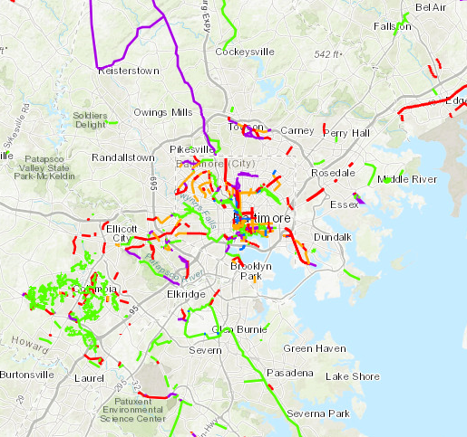 |
Information includes location, facility type, side of road, trail or road name (if applicable), and speed limit (if applicable). Bicycle trails that do not aid in commuting, such as a small loop in a park, may not be represented on the Regional Bicycle Facility Map.
The new data can be accessed through an online mapping application. For planners and advanced data users, the raw GIS data is available on BMC’s website.
The Regional Bicycle Facilities Map is a collaborative product of BMC, the Baltimore Regional Transportation Board’s (BRTB’s) Bicycle and Pedestrian Advisory Group (BPAG), county planning and GIS partners from the Baltimore region, the Maryland Department of Planning, Maryland Department of Transportation, and the Maryland Department of Natural Resources.