The Baltimore Regional Transportation Board (BRTB), as the metropolitan planning organization for the Baltimore region, seeks public comments through Friday, June 11 on a new section of the Patapsco Regional Greenway in Carroll County and Howard County.
In 2017, the BRTB approved a concept plan for the Patapsco Regional Greenway, which will be used by bicyclists, hikers, runners, walkers, and in some locations, equestrians. To date, over 12 miles of the greenway have been completed. Now, the BRTB seeks your input on the Sykesville to McKeldin Segment, which will add another 8.5 miles to the greenway.
Details about the comment period and how to provide comments are available below.
About the Patapsco Regional Greenway
The Patapsco Regional Greenway maps the main alignment of a 40-mile, shared-use trail traveling through the Patapsco Valley from Sykesville in Carroll County to Baltimore’s Inner Harbor. The trail, when completed, would pass through or near the communities of Sykesville, Marriottsville, Woodstock, Daniels, Oella, Ellicott City, Catonsville, Elkridge, Halethorpe, Baltimore Highlands, and Cherry Hill. The Patapsco Regional Greenway will serve as a region-wide asset and provide nearby communities with a sustainable transportation route and miles of recreational trails.
About the Sykesville to McKeldin Area Project
The Sykesville to McKeldin Segment of the Patapsco Regional Greenway consists of two sections - 1) the western portion near downtown Sykesville and 2) the eastern portion near the McKeldin area of the Patapsco Valley State Park.
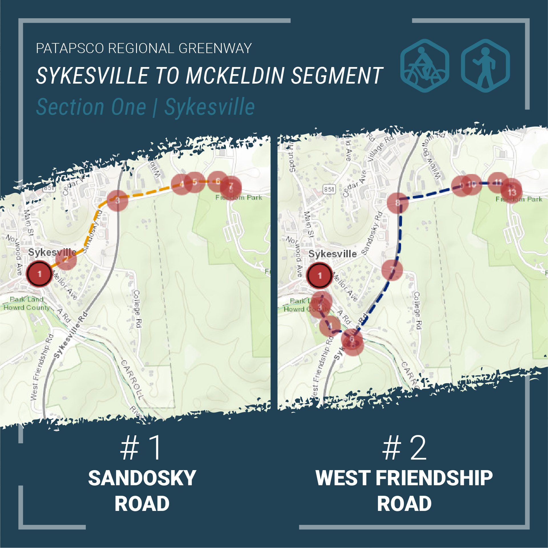
Section 1 - Western Portion: Main Street Sykesville to Freedom Park
The western portion will connect downtown Sykesville shops, dining, and residences along Main Street to active and passive recreation opportunities in Freedom Park. There are two alignment alternatives for Section 1 - Western Portion: Main Street to Freedom Park.
- Alignment 1: Sandosky Road
A shared-use trail travels from Main Street in downtown Sykesville, then north along Sandosky Road to Raincliffe/Buttercup Road intersection, and finally into Freedom Park. - Alignment 2: MD 32
Begins on Main Street in downtown Sykesville and travels south. The shared-use trail crosses the Patapsco River and turns onto West Friendship Road. The trail then turns onto River Road and travels south. The trail re-crosses the Patapsco River along an abandoned vehicular overpass and continues north along MD 32 to rejoin the sidewalk on Raincliffe Road. And finally the trail travels briefly south from the Raincliffe/Buttercup Road intersection into Freedom Park.
Both options will explore sidewalks and paved pathways to accommodate safe and comfortable use by pedestrians and bicyclists.
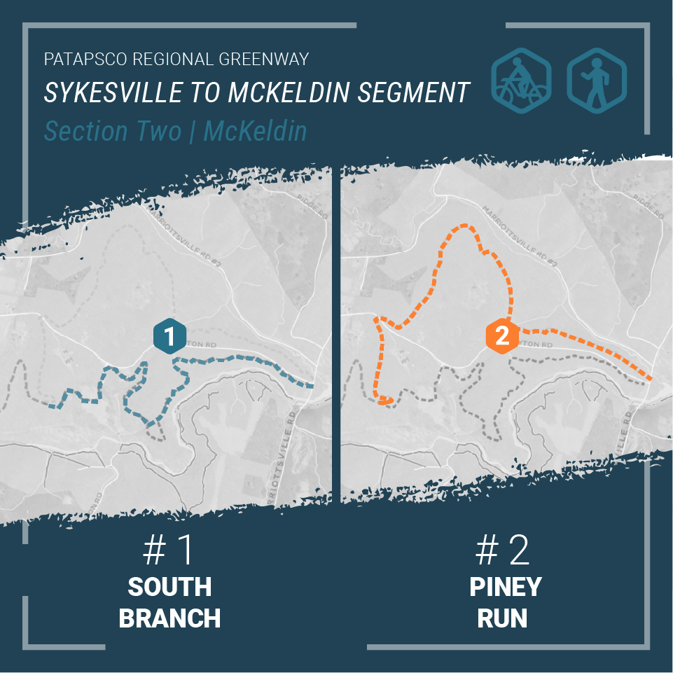
Section 2 - Eastern Portion: Freedom Park to the McKeldin Area in Patapsco Valley State Park
The eastern portion of the shared-use trail will connect Freedom Park with the McKeldin Area of the Patapsco Valley State Park. There are two alignment alternatives for Section 2 - Eastern Portion: Freedom Park to McKeldin Area.
- Alignment 1: South Branch
Meanders through Patapsco Valley State Park towards the Heart of Maryland Bowhunters Club property. From there, the shared-use trail veers south towards the South Branch of the Patapsco River. The trail then follows the South Branch to Marriottsville Road and crosses Marriottsville Road before ending in the McKeldin area of the Patapsco Valley State Park. - Alignment 2: Piney Run
Follows the same path as Alignment 1: South Branch until the shared-use trail passes beyond the Heart of Maryland Bowhunters Club property. The trail then travels north up and around the League of Maryland Horsemen property towards Piney Run. The trail veers south and parallels Piney Run until the trail reaches Marriottsville Road. After crossing Marriottsville Road, the trail follows the Alignment 1: South Branch before ending in the McKeldin Area of the Patapsco Valley State Park.
Both options will follow a similar path through the Patapsco Valley State Park encountering dense forest, scenic views, ruins of abandoned structures, stream crossings, and many other points of interest. The design will also celebrate the natural and cultural wonders of the park integrating high overlooks, rock formations, and archaeological treasures. The natural surface trail will serve hikers, mountain bikers, and equestrian riders with a sustainably constructed unpaved trail.
The purpose of this project is to explore the opportunities and challenges of the alignments, identify design details, engage the public in key decisions, and prepare a 30% design document that will carry the project into final design and construction.
View the alignment options in our StoryMap |
Share Your Thoughts
The public is invited to share their feedback on the alignment alternatives for the Patapsco Regional Greenway: Sykesville to McKeldin Segment from Thursday, May 6 through Friday, June 11.
There are six ways you can comment:
- View the StoryMap and take our survey
- Join us for a public meeting on Thursday, May 27 at 6:30 p.m.
- Email your thoughts to M503@PublicInput.com
- Text M503 to 73224 to share your thoughts
- Call us at 855-925-2801, x 7772 and leave a voicemail with your feedback
- Share your thoughts via Twitter at @BaltoMetroCo | @BmoreInvolved | #BRTBlistens
For more information:
Contact Keith Kucharek, Transportation Planner, by email at kkucharek@baltometro.org, or by phone at 410-732-0500 x1052.
Notice
The Baltimore Regional Transportation Board operates its programs and services without regard to race, color, or national origin in accordance with Title VI of the Civil Rights Act of 1964, and other applicable laws. Appropriate services can be provided to qualified individuals with disabilities or those in need of language assistance who submit a request at least seven days prior to a meeting. Call 410- 732-0500. Dial 7-1-1 or 800-735-2258 to initiate a TTY call through Maryland Relay. Si se necesita información de Título VI en español, llame al 410-732-0500.